Sustainable Drainage System Design Services: 2026 Guide
Table of Contents
- What Sustainable Drainage System Design Services Cover
- Step 1: Site Assessment and Feasibility
- Step 2: Meeting LLFA SuDS Planning Requirements
- Step 3: Writing a SuDS Drainage Strategy Report
- Step 4: CIRIA SuDS Manual Compliance and Technical Design
- Retrofitting SuDS in Existing Urban Environments
- Common Mistakes to Avoid
- Frequently Asked Questions
Last Updated: September 26, 2026
What Sustainable Drainage System Design Services Cover
Sustainable drainage system design services cover the full process of planning, modelling and documenting surface water management for a development, from the first site visit through to a drainage strategy that satisfies the Lead Local Flood Authority. At The Drainage Designers, we handle site assessment, infiltration testing, hydraulic modelling and the planning submission itself. Most projects need this input early, because drainage now sits at the centre of whether a planning application succeeds or stalls.
The work splits into four pillars.
The Four Pillars of SuDS Design
Water quantity controls discharge rates and volumes so the site does not increase flood risk downstream. Water quality treats runoff before it leaves the site. Amenity covers how the system looks and functions as usable space. Biodiversity covers habitat value, which now links directly to biodiversity net gain requirements.
When a Project Needs a Drainage Design Consultant
You need a drainage design consultant when your application triggers a flood risk assessment, when the site sits in Flood Zone 2 or 3, when you are adding impermeable area, or when your local authority asks for a drainage strategy. Small extensions sometimes fall outside this. Larger domestic projects and almost all commercial schemes do not.
Ask your local planning authority for its validation checklist before you commission any design work. Many rejections happen because the drainage information submitted did not match the checklist, not because the design was poor.
Step 1: Site Assessment and Feasibility
Site assessment is where good schemes are made or lost. Before any design work starts, the site needs a proper assessment of ground conditions, levels, existing drainage and how water currently behaves across the catchment area. This is not a box-ticking exercise; it is the evidence base that determines whether your drainage strategy will be approved or refused.
Geotechnical Survey and Infiltration Testing
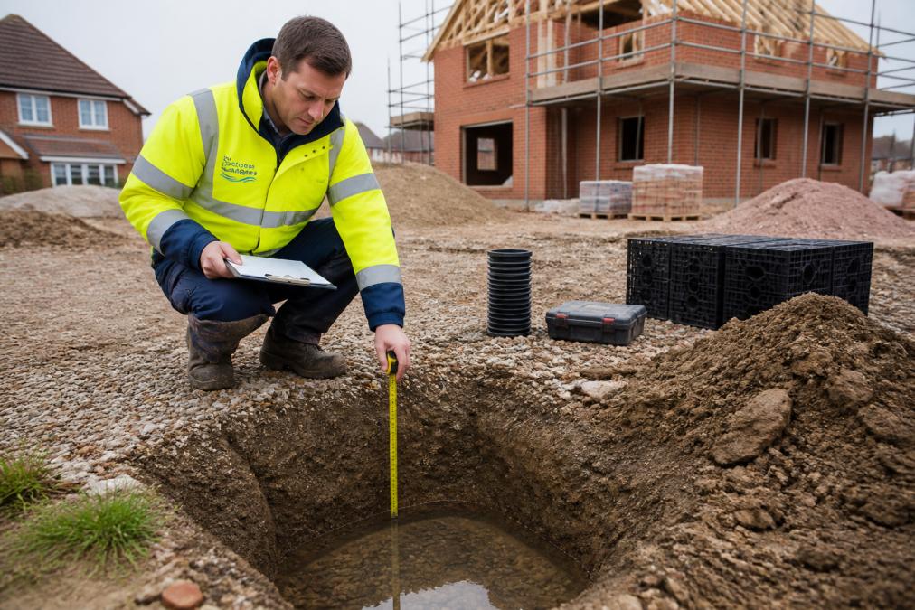
Infiltration testing tells you whether the ground can absorb water and how fast. A soakaway test pit, dug to the right depth and filled in line with recognised procedures such as BRE Digest 365, gives you an infiltration rate you can design to. Without it, any soakaway or permeable paving design is guesswork. The test must be carried out at the depth and location of the proposed infiltration feature, and the results should include the date, location, soil conditions and calculated infiltration rate.
Regulatory Context for Site Assessment
Under the Town and Country Planning Act 1990 and the National Planning Policy Framework, local planning authorities require a flood risk assessment for sites in Flood Zones 2 and 3, and for sites over one hectare in Flood Zone 1. The Lead Local Flood Authority (LLFA) is a statutory consultee on surface water drainage for major developments, and its validation checklist often mandates specific site assessment information before the application can even be registered.
Most LLFAs expect the following as a minimum:
- Infiltration test results with locations, dates and calculated rates
- Groundwater monitoring data if the site is within a Source Protection Zone
- Existing drainage plans and evidence of any culverted watercourses
- Topographical survey showing levels and flow routes
- Evidence that the drainage hierarchy has been followed
Interpreting Results and Making Design Decisions
Once you have the data, the design decisions follow. An infiltration rate below 1 x 10^-5 m/s is generally considered unsuitable for soakaways, and you will need to look at attenuation and controlled discharge instead. If groundwater is high, you may need to line the infiltration feature or use a raised system. If contamination is present, you must consider whether infiltration would mobilise pollutants and whether a remediation strategy is needed.
Step 2: Meeting LLFA SuDS Planning Requirements
LLFA SuDS planning requirements are the standards your local lead local flood authority applies when it reviews your application. The authority is a statutory consultee, and its objection can hold up or stop a scheme regardless of how good the rest of the application is.
What the Lead Local Flood Authority Expects
Most authorities want to see the drainage hierarchy followed, meaning you have demonstrated why above-ground and infiltration options were or were not used before resorting to piped solutions. They want discharge rates limited to greenfield runoff rates where feasible, and they want evidence, not assertion.
- A clear plan showing catchment areas and flow routes
- Infiltration test results with locations and dates
- Proposed discharge rates and the calculations behind them
- How the system performs during exceedance events
- Maintenance arrangements for the life of the development
Step 3: Writing a SuDS Drainage Strategy Report
A SuDS drainage strategy report is the document that explains your drainage design to the planning authority, sets out how the hierarchy was applied, and proves the scheme meets policy. It is the core deliverable, and it needs to read as a complete argument rather than a set of drawings with notes.
Step 4: CIRIA SuDS Manual Compliance and Technical Design
CIRIA SuDS manual compliance means your design follows the industry standard reference for SuDS, covering hydraulic performance, water quality treatment and construction detail. The manual is the document designers, authorities and contractors all work from, so aligning to it removes arguments before they start. But compliance is not just about ticking boxes; it is about demonstrating that your design will perform under the conditions it will actually face over its lifetime.
Choosing the Right Components for the Site
Component choice follows the site, not the other way round. Ground conditions, available space, levels, contamination and maintenance appetite all narrow the options.
| Component | Best For | Main Constraint |
|---|---|---|
| Soakaways | Free-draining ground | Needs good infiltration rate |
| Permeable paving | Driveways and parking | Regular maintenance required |
| Swales and bio-retention | Larger sites with space | Land take |
| Attenuation tanks | Tight sites, clay ground | Below-ground footprint |
| Detention ponds | Amenity and biodiversity value | Space and safety design |
Climate Change Resilience Modelling
Climate change resilience modelling is the process of testing your drainage design against future rainfall scenarios, not just historic records. The Environment Agency’s current guidance requires developers to add a climate change allowance to peak rainfall intensity, typically 40% for the 2080s central estimate, but this can be higher depending on the region and the vulnerability of the site.
Do not assume that a standard climate change allowance is sufficient. The Environment Agency updates its guidance periodically, and some LLFAs require a higher allowance for sensitive sites. Always check the current requirements for your area before finalising your hydraulic model.
Water Quality and Amenity
CIRIA compliance also requires water quality treatment to be addressed. The manual sets out a treatment train approach, where runoff passes through a series of components to remove pollutants. This might include permeable paving, swales, bio-retention and a detention pond. Each component provides a level of treatment, and the combination must be sufficient to protect the receiving watercourse.
Documentation and Evidence
Your technical design must be documented in a way that demonstrates compliance. This includes:
- Hydraulic modelling reports showing the design storms and climate change scenarios tested
- Water quality treatment calculations
- Component specifications and manufacturer details
- Maintenance schedules and access arrangements
- Evidence of how the design follows the drainage hierarchy
Retrofitting SuDS in Existing Urban Environments
Retrofitting SuDS into existing urban environments is harder than new build, because space is fixed and drainage already exists. The goal shifts from designing a system from scratch to intercepting surface water runoff before it reaches an overloaded network.
Never connect a new soakaway or infiltration feature without checking the groundwater and contamination position first. On contaminated land, infiltrating water can mobilise pollutants and create a liability that outlasts the project.
Common Mistakes to Avoid
The most expensive mistakes happen before design starts. Commissioning drawings without infiltration testing, ignoring the local authority’s validation checklist, and submitting a strategy that does not follow the drainage hierarchy account for a large share of refusals and delays.
Other repeat offenders:
- Treating the flood risk assessment and drainage strategy as one document when they are separate requirements
- Designing to a discharge rate without checking what the receiving watercourse or sewer can accept
- Leaving maintenance arrangements vague, which invites planning conditions
- Assuming every authority wants the same format
The cheapest place to fix a drainage problem is at feasibility stage. Every issue found after submission costs time, fees and a resubmission.
Frequently Asked Questions
Is SuDS a legal requirement for new developments?
SuDS are not a standalone legal requirement, but since 2015 major developments must use sustainable drainage unless demonstrated impractical. Schedule 3 of the Flood and Water Management Act 2010 is being implemented to make SuDS approval mandatory. In practice, Local Planning Authorities and the Lead Local Flood Authority expect a compliant drainage strategy for most new builds, extensions and conversions. Sustainable drainage system design services help you meet those expectations first time.
How do I prepare a SuDS statement for a planning application?
Start with a site assessment covering soil infiltration rates, catchment area and existing surface water runoff. Then set out your drainage strategy using the water management hierarchy, showing how you will manage discharge rates and water quality. A SuDS drainage strategy report should include hydraulic modeling, proposed components such as soakaways, attenuation tanks or permeable paving, and maintenance arrangements. Early engagement with the Lead Local Flood Authority reduces the risk of conditions or refusal.
How do I ensure my drainage design meets CIRIA standards?
CIRIA SuDS manual compliance requires following the C753 guidance on design, construction and maintenance. This means sizing components using hydraulic modeling, confirming infiltration rates through geotechnical survey, and selecting flow control devices appropriate to the discharge rate. Your technical design should also demonstrate water quality improvement and, where relevant, biodiversity net gain. A qualified drainage design consultant will document each step so the Lead Local Flood Authority can verify compliance.
What is the difference between permeable paving and attenuation ponds in SuDS?
Permeable paving allows surface water runoff to infiltrate directly through the surface into the ground or a sub-base storage layer, making it suitable for driveways, parking areas and patios. Attenuation ponds store water temporarily before a controlled release into a watercourse or sewer at a restricted discharge rate. Ponds suit larger sites with space for detention, while permeable paving works well in tighter residential schemes. Many designs combine both to meet LLFA SuDS planning requirements.